
- The location of India extends between 8º 4 ‘ to 37º 6′ north latitude and 68º 7 ‘ to 97º 25′ east longitude north of the equator .
- To the east of the Indian subcontinent lies the Bay of Bengal, the Arabian Sea to the west and the Indian Ocean to the south.
- The area of India is 32,87,263 sq km. is.
- India is the seventh largest country in the world after Russia, Canada, China, America, Brazil and Australia and second largest in terms of population after China.
- The length of India from north to south is about 3214 km and the length from east to west is about 2933 km.
- The extension of India is 30º from 68º 7 ‘ longitude line in the west of India and 97º 25′ longitude line in the east.

- Moving from west to east, there are a total of 360º longitude lines on the earth. It takes 24 hours (1440 minutes) for the Earth to rotate 360º.
- The Earth crosses the 1º longitude in 4 minutes, so it takes about 120 minutes for the Earth to rotate from the western end of India (68º7 ‘east longitude) to the eastern end (97º25’ east longitude). There is a difference of 2 hours between Arunachal Pradesh and Gujarat.
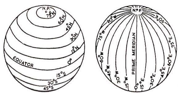
- In countries with more longitudinal expansion in the world, the longitudinal line of the middle is considered as the standard time line. Therefore, the time that will be there is accepted as the standard time of the whole country.
- To solve this problem in India, 82½º longitude line has been accepted as Standard Meridian for determining the Standard Time (IST) of India. In this way, the time on the 82½º meridian line will be considered as the time of the whole country.
- The international standard time line 0º longitude passes through a place called Greenwich, London.
- The time interval from 0º longitude to 82½º east longitude is 5 hours 30 minutes, since India is located in the Eastern Hemisphere, so Indian Standard Time (82½º East Longitude) is 5 hours 30 minutes ahead of Greenwich Time. That is, if it is 5:30 in the evening in India, then it will be 12:00 in London.
- The Indian Standard Timeline passes through 5 states of India – Uttar Pradesh , Madhya Pradesh , Chhattisgarh , Odisha and Andhra Pradesh .
- The northern latitude line 23½º or the tropic of Cancer passes through almost the middle of India, due to which it divides the entire country into two regions – tropical in the south and sub-tropical in the north.
- The Tropic of Cancer passes through Bangladesh between West Bengal and Tripura. The longest length of the Tropic of Cancer in India is in the state of Madhya Pradesh and the minimum length is in Rajasthan.
- The Tropic of Cancer passes through eight states of the country, which follows from west to east – Gujarat , Rajasthan , Madhya Pradesh , Chhattisgarh , Jharkhand , West Bengal , Tripura and Mizoram.
- The total length of India’s coastal border is 6100 km, but adding the length of the mainland and islands also, the total length is about 7517 km. The total length of India’s land boundary is about 15,200 km.
- 9 states of India – Karnataka , Kerala , Tamil Nadu , Andhra Pradesh , Odisha , West Bengal , Gujarat , Maharashtra and Goa and 5 Union Territories – Puducherry , Lakshadweep , Andaman and Nicobar Islands , Dadar and Nagar Haveli and Daman and Diu borders the coastline.
- The southern part of the Indian peninsula is triangular, surrounded by the Indian Ocean in the south, the Bay of Bengal in the east and the Arabian Sea in the west. Apart from this, some other narrow creeks and channels exist around the Indian peninsula.
- The narrow sea in the south of Gujarat is called the Gulf of Khambhat, the narrow sea in the west of Gujarat is the Gulf of Kutch and the narrow sea between India and Sri Lanka is called the Gulf of Mannar.
- The narrow sea between the two islands is called the Channel. Channels located around India are named after latitude lines. For example, the 8º channel between Maldives and Minikaya is situated to its north, the 9º channel between Minikaya and Lakshadweep and the 10º channel between Little Andaman and Car Nicobar.
- Gujarat is the longest coastline state in India and Andhra Pradesh and Tamil Nadu are the second and third longest coastline states respectively.
- Goa is the shortest coastline state in India .
- The southernmost point of the Indian peninsula is Kanyakumari , but the southernmost point of India is Indira Point located in Great Nicobar .
- The northernmost point of India is Indira Call (Jammu and Kashmir) and the westernmost point is Guhar Mota (Gujarat), while the easternmost point is Kibithu (Arunachal Pradesh).
- India shares land borders with 7 countries China and Nepal in North, Pakistan and Afghanistan in north-west, Bangladesh and Myanmar in east and Bhutan to the north east.

- Except Pakistan and Bangladesh (because India’s borders with them are artificial or man-made), India has natural borders with Afghanistan, China, Nepal, Bhutan and Myanmar.
Note: On October 31, 2019, a new Union Territory of Ladakh has been carved out of the state of Jammu and Kashmir, which borders China, Afghanistan and Pakistan.
- Borders with India and neighboring countries –
- Durand Line: – Durand Line is presently the boundary line between Pakistan and Afghanistan. When the country was not partitioned before independence, the border line of British India and Afghanistan was called Durand Line.
- McMahon Rekha: – The border that forms with China and Arunachal Pradesh is called the McMahon Rekha. It was determined by Henry McMahon in 1914 during the Simla Agreement.
Note: The line along the whole of India and China is not called the McMahon Line.
- Radcliffe Line: – The border of India and Pakistan is towards the north-south, it is called the Radcliffe Line. The Radcliffe line was determined by Sir Radcliffe on 15 August 1947 between India and Pakistan.
- Indian states touching the border of India’s neighboring countries –
- Pakistan – Jammu and Kashmir, Ladakh, Punjab, Rajasthan and Gujarat.
- China – Ladakh, Jammu and Kashmir, Himachal Pradesh, Uttarakhand, Sikkim and Arunachal Pradesh.
- Myanmar – Arunachal Pradesh, Nagaland, Manipur and Mizoram.
- Bangladesh – Mizoram, Tripura, Assam, Meghalaya and West Bengal
- Nepal – Uttarakhand, Uttar Pradesh, Bihar and West Bengal
- Bhutan – Sikkim, West Bengal, Assam and Arunachal Pradesh
- The states of India, surrounded by India’s neighboring countries-
- Sikkim – is surrounded by Nepal, China and Bhutan.
- West Bengal – is surrounded by Nepal, Bhutan and Bangladesh.
- Ladakh – is surrounded by China, Afghanistan and Pakistan.
Note: The border of Afghanistan only touches Jammu and Kashmir (Pakistan Occupied Kashmir), which now only touches the state of Ladakh in the new map released by the Government of India.
- At present, there are a total of 28 states and 9 union territories in India. Earlier there were 28 states and 7 union territories in India.
- On August 5, 2019, the special state of Jammu and Kashmir was abolished and made into two separate union territories, in which Jammu and Kashmir was given the status of a union territory with the same legislative assembly as Delhi and a new Union Territory of Ladakh (Jammu and Separated from Kashmir). Both these union territories came into full existence from October 31, 2019. Thus, there are a total of 28 states and 9 union territories in India.
- The 5 largest states in terms of area in the states of India are Rajasthan, Madhya Pradesh, Maharashtra, Uttar Pradesh and Andhra Pradesh respectively. Before the formation of Telangana state, Andhra Pradesh was the fourth largest state in the country in terms of area.
- Goa is India’s smallest state in terms of area.
- Sikkim is the smallest state of India in terms of population.
- Among the states / union territories, Lakshadweep is the smallest state in India in terms of area.
- Uttar Pradesh is the state of India that borders most states. It forms a border with eight states of India and a union territory, which is as follows – Uttarakhand, Himachal Pradesh, Haryana, Rajasthan, Madhya Pradesh, Chhattisgarh, Jharkhand, Bihar, and Union Territory of New Delhi.
- The largest district in terms of area of India is Kutch district of Gujarat and the smallest district is Mahe district of Pondicherry. There are about 6,41,000 villages in India.
- Important facts related to Union Territories –
- Chandigarh is not only a union territory but also the capital of Punjab and Haryana.
- New Delhi is the national capital of India.
- Dadar Nagar is situated on the border of Maharashtra and Gujarat states.
- Pondicherry is located at a total of 4 places, which is spread over three states-
(i) Mahe – Kerala
(ii) Pondicherry and Karaikal – Tamil Nadu
(iii) Yanam – Andhra Pradesh
- Apart from the mainland of India, two islands are Andaman and Nicobar islands in the Bay of Bengal and Lakshadweep in the Arabian Sea are part of our country.
important facts
- 82½º meridian Line passes through a place called Naini in Prayagraj district of the state of Uttar Pradesh.
- The longitude 0º (zero degree) passes through the city of Greenwich, London.
- Indian Standard Time – IST (82½º) Greenwich Average Time – 5 hours 30 minutes ahead of GMT.
- Ranchi, the capital of Jharkhand is located on the Tropic of Cancer (23½º North Latitude). Apart from this, two other major cities Gandhinagar, the capital of Gujarat and Bhopal, the capital of Madhya Pradesh, are situated very near to the south of the Tropic of Cancer.
- Indira Point in Great Nicobar is also known as Pigmalion.
- Kanyakumari, the southernmost point of the Indian continent, is also known as the ‘Cape of Comorin’.
- India’s northeastern state of Tripura is surrounded on three sides by Bangladesh.
- Sri Lanka is separated from India by the Pak Strait.
- The closest country to India across the sea is Sri Lanka, which is separated from Tamil Nadu by Indian territory through the Palk Strait. It connects the Bay of Bengal to the Gulf of Mannar. It is named after the then Madras Presidency Governor Robert Pak (1755–63).
